
Native American Mapping
The ability to make maps appears to be hard wired into the human brain. People orient themselves in space through the construction of cognitive or “mental maps” (which exist only in the mind). This faculty for spatial orientation is important for human survival, and the origins of this ability probably antedate the appearance of modern humans.[1] The earliest known maps to make the transition from mental images to a durable medium are prehistoric pictographs and petroglyphs, some of which probably antedate the appearance of writing.[2]
Thus, it is certain that New York’s aboriginal inhabitants were also its first map makers, although we can only speculate about the appearance of maps produced prior to the period of European contact. Recent research has shown that many American Indian cultures made maps, some of which were quite sophisticated.[3] Unfortunately, any “mental maps” that pre-contact Indians in New York may have transferred to a physical medium have been lost. This is not surprising, since Indian maps were usually created as temporary sketches to illustrate verbal descriptions of travels or military ventures. Early explorers report that they often were drawn in the dirt or sand. Although a few Indian maps took the form of pictographs or other images on stone, no maps of this kind have been found in New York. Iroquoian groups in Canada are reported to have made maps on birch bark, but no bark maps made by New York Indians prior to the nineteenth century have survived.[4]
On the other hand, there are reports of maps being sketched out by Indians for the early European explorers of what is now New York. One of the first of these is by an Indian who in 1619 sketched out in chalk a map of the rivers around Manhattan for the English explorer Thomas Dermer.[5] Somewhat later, in the well-known “Narrative of a Journey into Mohawk and Oneida Country” (1634-35), it is related that Oneida Indians made a map of their country for Dutch explorers using stones and grains of corn.[6] Several copies of Indian maps showing portions of New York, which were made by Europeans, have also come down to us. One of the most spectacular of these is a map of the area around Susquehanna River made in 1683 by two Cayugas and a Susquehannock.[7] A somewhat similar map showing Indian routes from the Susquehanna River to the Iroquois villages was made in 1681.[8] Since these latter maps date from well after the initial contact between Indians and Europeans, and were put on paper by Europeans, it is possible that they reflect some European influences in their techniques.
Throughout the colonial period, Native Americans continued to provide information that found its way into maps made by Europeans. In some cases these contributions were acknowledged. As late as 1771, Guy Johnson’s map of the country of the Six Nations credited information derived from “sketches of intelligent Indians.”[9] In other cases, we can deduce the borrowings from Indian sources through the analysis of certain features on European maps. For example, Indian maps are not based on European conceptions of uniform scale or the location of places by coordinates of latitude and longitude. They tend to exaggerate the size of important features, such as islands in lakes, and frequently “misplace” or “misorient” things according to our lights. Since most Indian maps were made for purposes of hunting, trade, or war, they also frequently emphasize communication routes by water, without showing the relative sizes of different steams, or even differentiating between streams and portages. When we see these characteristic features on European maps, it is probable that they are derived from unacknowledged Native American sources. Indian contributions to colonial-era maps, both acknowledged and unacknowledged, will be discussed in greater detail as we come across them on particular maps.
Maps of the Early European Explorers, 1500-1600
It is not certain when the first European set foot on present-day New York. It is possible that the Vikings reconnoitered this far south, but no generally accepted archaeological or documentary evidence has so far been uncovered that proves a Viking presence here.[10] It is also possible that other European fishermen or explorers may have touched upon the shores of New York before 1492, but no solid evidence has been found to confirm this possibility. All widely accepted evidence of European discoveries in New York postdates Columbus. Even here, it is uncertain which European was the first to sight New York. Two early maps of the east coast of North America may possibly show the coastline of present-day New York. One of these is the famous world map of Juan de la Cosa (1500), which presents the east coast of North America in very stylized fashion.[11] A stronger case can be made that the Cantino chart of 1502 shows the results of an actual voyage along the coast of North America, since it contains more details and some place names. Arne Molander has argued plausibly that this map shows the coast of Long Island and Montauk Point, and that it reflects the discoveries of a Portuguese expedition headed by the Corte Real brothers.[12]
The first certain sighting of New York by a European was made by Giovanni da Verrazano in 1524. Verrazano, after sailing over the site of the future Verrazano Bridge, anchored briefly in New York Bay. He then sailed along the coast of Long Island (which he called “Flora”), passed Block Island (“Louisa”), and proceeded to Narragansett Bay, where he overhauled his ship. Verrazano’s discoveries are recorded in several manuscript maps drawn in the 1520s, including the Maggiolo world map of 1527, and maps by Girolamo Verrazano (the explorer’s brother) created in 1529.[13] These are all small-scale maps; a better representation of Verrazano’s discoveries is presented in Gastaldi’s map of New France, which was published later in 1556. The Gastaldi map, which also incorporates information from Cartier’s voyages, will be discussed below.
Verrazano’s voyage was sponsored by the King of France (Francis I). Not to be outdone, his Habsburg rival, the Emperor Charles V, dispatched his own expedition later in the same year to explore the east coast of North America. This was led by Esteban Gomez, a Portuguese explorer, who had previously sailed with Magellan (and had deserted him before he rounded South America). We know that Gomez sailed past New York, going from north to south, but it is doubtful whether he actually saw New York Harbor or any areas immediately surrounding it. He seems to have kept so far off shore that he could gather at best only a vague impression of the coast. There is a whole group of maps based on the voyages of Estaban Gomez. They show the East Coast of North America, but their depiction of the New York area is extremely unclear. The earliest most influential of this group is Diogo Ribero’s World Map (1529), which set the standard for the depiction of the east coast between Cape Cod and Chesapeake Bay until the explorations of Henry Hudson. A conspicuous feature on these maps is a large river with many islands at its mouth labeled “Rio de las Gamas” (Deer River). Some have thought that this might be New York Harbor, but the river is clearly north of Cape Cod, and is almost certainly the Penobscot Bay and River.[14]
The next explorer to contribute to the exploration of New York was Jacques Cartier (1491-1557). Cartier made three voyages between 1534 and 1542, in which he explored the Gulf and River of St. Lawrence as far as the present site of Montreal. In none of these voyages did Cartier actually enter the boundaries of present-day New York, although he apparently saw the Adirondack Mountains from Mont Royal near Montreal. He spent considerable time with Iroquoian Indians (possibly Huron) near the sites of what later became Quebec and Montreal, and learned from them about the existence of the Great Lakes and Lake Champlain, as well as something about the Iroquoian tribes in what is now New York. Cartier’s explorations formed the basis of the French claim to the St. Lawrence River Valley, and led to later French activities in northern New York, including extensive mapping.[15]
Of the maps reflecting these early voyages, the most revealing is Giacomo di Gastaldi’s map of New France, which was published in Ramusio’s Viaggi (Voyages) in 1556 (Figure 1.1).[16] One would like to know more about the sources of this map, but it clearly drew on the narratives of both Verrazano and Cartier, which are both included in Ramusio’s book (The Viaggi was an early collection of travel narratives and a predecessor of Hakluyt’s Voyages.) Gastaldi’s map, which is the first regional map of the Northeast, looks crude and very strange to our eyes, but its basic features are clear enough. New York harbor is labeled Angoulême (the title of Francis I before he became king). The embayment to the right of New York Harbor is probably Jamaica Bay, which was much more open to the ocean at that time. Long Island is the peninsula labeled Flora. Narragansett Bay and probably Buzzard’s Bay are shown on the mainland. Narragansett Bay seems to be Port Réal , and Buzzard’s Bay is probably Port du Refuge, although the map seems to reflect some confusion between the two. Practically nothing is shown of the coastline between Buzzard’s Bay and Cape Breton. The odd snake-like object in the ocean is a stylized representation of the Grand Banks and the shoals off Cape Cod. One of the most interesting features of this map is the depiction of the Hudson and St. Lawrence Rivers, which are shown as joining. This is probably an indication of the use of Native American sources. Rivers do not cross watersheds, but Indians carrying canoes do, and, as previously mentioned, Native American maps often do not differentiate between streams and portages. Indians made trips from the St. Lawrence to the Hudson River via the route that runs through the Richelieu River, Lake Champlain, and Lake George. Since this route was as yet unexplored by Europeans, this feature almost certainly reflects knowledge derived from Native American sources. It appears also that the Mohawk River may be shown flowing to the west where the Hudson River “joins” the St. Lawrence. If this is actually what is represented here, this information would also have come from Indians.[17]
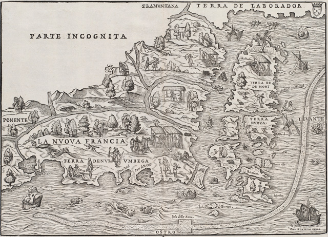
Figure 1.1 Giacomo di Gastaldi, Map of New France, 1565. Courtesy of the Norman B. Leventhal Map Center at the Boston Public Library.
Even at this early date, the Gastaldi map already reflects a salient feature of New York’s geographyone that is critically important for the subsequent exploration, mapping, and settlement of the region. This is the easy access to the interior of New York and the continent via rivers and inland waterways. New York is bounded on the north and west by the St. Lawrence River, and by the Great Lakes. The Hudson River penetrates its center. These great inland passages are joined by relatively easy routes via Lake Champlain and the Mohawk River. These waterways largely explain New York’s strategic position as an entryway to the North American continent.
Unfortunately for the French, they fell into a period of civil war shortly after the time the Gastaldi map was made, and did not resume their explorations in North America until the first decade of the seventeenth century. During the fifty years following the publication of the Gastaldi map, there were no significant improvements in the mapping of what is now the Northeastern United States. Verrazano’s discoveries were almost forgotten, and maps of this area were typically based on the model established by the Ribero chart with its indistinct depiction of the New York area. The popularity of the maps based on the explorations of Estaban Gomez reflects the reputation of the Spanish as the foremost explorers of the sixteenth century. Only after 1600 did the French resume their explorations, and by that time the English and the Dutch were also on the scene. A period of relatively rapid exploration and mapping ensued, stimulated in part by rivalry between the three nations.
Hudson, Champlain, and Their Successors, 1603-1632
The first decade of the seventeenth century was pivotal for later developments. In 1603 Champlain arrived in New France, and French explorations were vigorously resumed. The English founded Jamestown in 1607, and were active in exploring parts of what later became New England. Of most direct relevance to New York, Henry Hudson rediscovered New York harbor in 1609, and sailed up what is now known as the Hudson River to its limit of navigation near Albany.
Hudson’s voyage was by no means a complete shot in the dark. Although Verrazano’s discoveries had been overshadowed, they were not completely forgotten, and they were apparently supplemented by some unrecorded voyages made to the New York area later in the sixteenth century. A world map by Jehan Cossin dating from 1570 seems to show the area around New York Harbor, including (possibly) Long Island, along with the Hudson River flowing into a large lake, which might represent one of the Great Lakes or even Hudson’s Bay.[18] An account of Verrazano’s voyage was translated and published in Hakluyt’s Principal Navigations (1598-1600). This same edition of Hakluyt also includes a world map by Edward Wright, which appears to show the Hudson River flowing north to the St. Lawrence River, which then leads to “The Lake of Tadouac, the boundes whereof are unknowne.”[19] Probably acquaintance with some or all of these materials led John Smith to write Hudson from Virginia that he should look for a large river or straight a few degrees north of the Virginia Colony.[20]
Hudson nonetheless thought he was making a new discovery, and he certainly can be credited with being at the right place at the right time. Because of the political situation in Europe, his “discovery” was the one that mattered for future developments. In spite of this, the immediate cartographic consequences of Hudson’s voyage are unclear. Hudson is known to have made maps of his discoveries, but they have been lost. On Hudson’s return from the New World, his charts were confiscated by the English when he was forced to stop in London, and they have never resurfaced. In Holland, Hudson and other members of his crew communicated the results of his voyage to the Dutch authorities, but the earliest map produced by the Dutch that shows New York Harbor and the Hudson River appears to be the Adriaen Block Chart of 1614, which will be discussed below.
Thus, it appears that no maps made before 1614 still exist that depict Hudson’s discoveries. In many histories the gap between 1609 and 1614 has been filled in with a discussion of something known as the “Velasco Map”(Figure 1.2). However, I have argued elsewhere that this map is almost certainly a nineteenth-century fake, and a number of scholars agree with me.[21] Just in case I am wrong, something should be said about this map, because, even if it is a forgery, it makes a good starting place for the consideration of the extent of European knowledge of the Northeast in the years immediately following Hudson’s discovery. The “Velasco map” does much more than show the results of Hudson’s voyage: it summarizes results of the European discoveries in northeastern North America made in the decade before 1610. This map supposedly was produced for the English court around 1610, and was acquired or copied by the Spanish Ambassador to the Court of Saint James, one Don Alonso de Velasco, who sent the map (or more likely a copy of it) back to the King of Spain. The author of the map is unknown, and Velasco’s role (assuming the map is authentic) was only that of a forwarding agent. It was believed that it reposed in the Spanish archives along with associated documents until it was rediscovered at the end of the nineteenth century by Alexander Brown.
Figure 1.2. A probable fake: the so-called “Velasco Map.” Image from Stokes, Iconography of Manhattan Island.
The contrast between the Velasco map and everything that went before it is remarkable. It is the first map that shows the Northeast coast of the United States in a form we can easily recognize. In fact, the modern appearance of the map first raised questions in my mind about its authenticity. Nothing closely resembling it is known from the first half of the seventeenth century, and its depiction of what is now southern Canada is more accurate than anything that Champlain, an expert cartographer who spent many years in the area, produced as late as 1632.
Even though it is probably a fake, the Velasco Map is still a skillful synthesis of several early seventeenth-century sources. The depiction of the Hudson River and the area around New York harbor is almost certainly derived from published accounts of Hudson’s voyages.[22] The area around the Saint Lawrence River and the Coast of New England is mostly derived from maps of Champlain, including his manuscript map of New England, now held by the Library of Congress.[23] Champlain was busy in 1604 and 1606 mapping the coast of New England as far south as the southern shore of Cape Cod and the Elizabeth Islands. What might have happened if Champlain had gone a bit farther and rediscovered New York Harbor prior to Hudson, is an interesting question for those who like to ponder the “what ifs” of history.
Other sources were also used in the construction of this map. The depiction of coast of North Carolina and Chesapeake Bay appears to be largely derived from John Smith’s map of Virginia. The depiction of parts of the coast of New England appears to be derived from accounts in Hakluyt’s Voyages.
The depiction of the New York area on the Velasco map is remarkable both because of what it includes and what it omits. The Hudson River is clearly shown, as are several of the features of New York Harbor, including Sandy Hook and Staten Island. The names Manahata and Manahatin can be found on both sides of the lower river. These names probably indicate Indian tribes, and appear to be located further north than Manhattan Island, possibly as far north as the Hudson Highlands, which are sketched in on the map. The map does not show Long Island as separate from the mainland, and it also did not show Manhattan as an island. Nor does it show any recognizable details on the coast of Connecticut or Rhode Island. In most respects, then, the Velasco map accords with what is known Hudson’s explorations in the New York regioni.e. that he sailed straight up the Hudson River, and did no additional exploring in the region before his return.
The sources for the depiction of northern New York are more of a mystery (assuming again that the map is authentic). The Velasco map includes a depiction of the Saint Lawrence River, which could only have been derived from Champlain’s first voyage to Canada in 1603, although Champlain had not yet published any maps of the area. As mentioned above, the overall depiction of the St. Lawrence River area is, however, very different from anything Champlain ever published. The map also shows a large inland lake, which is almost certainly Lake Champlain, although it had not yet been discovered by Europeans. This lake is connected to the St. Lawrence River by what appears to be the Richelieu River. But the lake depicted is much larger than Lake Champlain; it runs from west to east; and it is divided into two nearly equal parts. Possibly the two parts are meant to represent Lake Champlain and Lake George. The exaggerated size of the lakes, and the neglect of scale and proportions are characteristic of maps derived from Indian sources. We know that both Hudson and Champlain gathered information from the Indians. Because of the depiction of the Richelieu River and the failure to show the connections between Lake Champlain and the Hudson River, it is most likely that the information about the inland lake was gathered by Champlain, if indeed the map is not a fake. Further west is a much larger lake that could only be Lake Ontario, although no European is known to have seen it. Lake Ontario is left open to the west, suggesting that it might be the long sought after passage through North America to the Pacific Ocean. A river is shown arcing from the Hudson to Lake Ontario. This is strongly suggestive of the Mohawk River, which (with the help of a portage to Lake Oneida) does eventually lead to Lake Ontario. The source of all of this information would be (if the map is authentic) once again, most likely American Indians, who could have communicated it to either Hudson or Champlain. As Champlain is known to have gathered geographical information from the Indians, he is the most likely source. The Velasco map acknowledges the use of information from Indian informantsthere is a note on the map located to the west of the Hudson River which states that “all the blue is done by the relations of the Indians.”
Almost all of the features on the Velasco Map were or could have been known to at least some Europeans in 1610, and this is what gives the map some value as a summary of European knowledge of New York as of that date, regardless of its authenticity. However, the map presents these features with a clarity and precision that cannot be found on other maps produced around that time, or even much later. In this sense, it is misleading, and gives the impression that Europeans had at this time a much clearer picture of eastern North America than they actually possessed. We will see that it took another fifty years of effort before European explorers and map makers were able to confirm the essential correctness of the picture presented by the Velasco Map.
Let us now turn to the maps of Champlain, the authenticity of which have not been seriously questioned. After completing his explorations of the New England coast, Champlain returned to the Saint Lawrence River area in 1608 and founded Quebec. The French were much interested in the fur trade, which got them involved in supporting Algonkian and Huron Indians against their traditional Iroquois enemies. The wars that ensued brought French troops repeatedly into northern and western New York. The first of these actions took place in 1609just as Hudson was exploring his eponymous river when Champlain and his Indian allies voyaged down the Richelieu River into Lake Champlain, and fought a successful skirmish at the bottom of the Lake, possibly near Fort Ticonderoga.
In 1612 Champlain published his first map of New France, which shows what he had learned of the geography of the area in the preceding years (Figure 1.3).[24] The Richelieu River is depicted, as well as Lake Champlain, which he apparently named after himself. The orientation and shape of Lake Champlain are approximately correct, although it is depicted as much too large, and shown far to the east of its true location. Champlain’s map also hints at the existence of the Adirondacks, which the explorer certainly would have viewed from “his” lake. It also shows the course of the St. Lawrence River, which he had explored as far as the rapids just beyond Montreal. Remarkably, the map also shows the remainder of the Saint Lawrence River, including the Thousand Islands, as well as Lake Ontario, Lake Oneida, Niagara Falls, and Lake Erie. Neither Champlain nor any other Frenchman had yet visited these places, and his sole sources of information for these features would have been American Indians. In certain respects, this part of the map, based entirely on Native American sources, is more accurate than any maps of the area that Champlain subsequently made.[25]
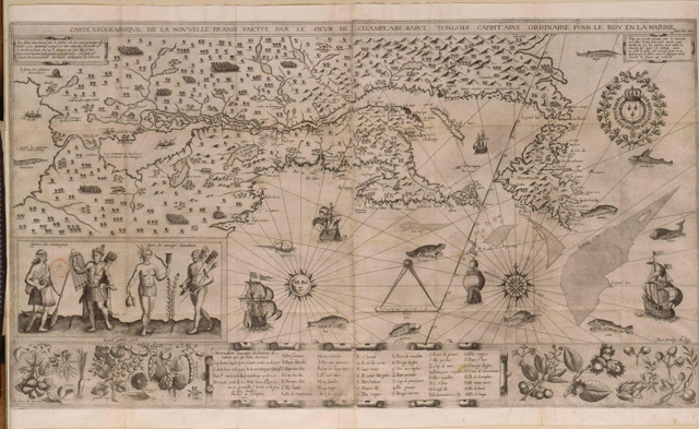
Figure 1.3. Samuel de Champlain, [New France] (1612). Detail of image from Bibliothèque nationale de France. Image source: Wikipedia Commons.
In the following years, Champlain was to see more of New York. He discovered Lake Huron by taking a route via the Ottawa River (he never reached Lake Erie). Then he backtracked and crossed Lake Ontario. Still fighting the Iroquois, he continued southward with his Indian allies and laid siege unsuccessfully to an Onondaga fort near Lake Oneida. Champlain’s narrative is accompanied by a drawing of a formidable looking Onondaga fort, which was published in the 1619 edition of his Voyages and Discoveries.. Like many of the illustrations on seventeenth-century maps, this drawing needs to be viewed with caution: it is by no means certain that the artist who made this engraving was supervised by Champlain. Based on what is known about Iroquois fortifications, the fort was probably much less elaborate than the one shown in Champlain’s book.
At about the same time, one of Champlain’s lieutenants, Etienne Brûlé, was sent on a mission to make contact with the Iroquois’ southerly enemies, the Susquehannocks (called by the French the Andastes). In the course his travels, Brûlé explored either the Delaware or the Susquehanna River to its mouth.[26] Most likely it was the Delaware River, since Champlain’s maps of New France made in 1616 and 1632 show the Delaware River reaching up to the Iroquois villages, and do not depict the upper reaches of the Susquehanna. There is a good chance that Brûlé, who was traveling with Indians, started his trip on a branch of the Susquehanna and portaged at some point over to the Delaware, but was unaware that he had changed rivers, or failed to communicate this to Champlain. It will be seen that the relationship between the two rivers also confused the Dutch, and it was not until the end of the seventeenth century that their intertwined watersheds were known at least approximately.
While Champlain was exploring northern New York, the Dutch were not idle. Hudson’s initial discovery was followed up by Dutch fur traders and explorers. After several preliminary voyages, a group of merchants sent a fleet of three ships to the vicinity of the Hudson River in the fall of 1613. The captain of one of these ships, de Tijger (The Tiger), was Adriaen Block, who was already on his third voyage to the Hudson River. Block was able to fend off threats from competing merchants, the destruction of his ship by fire, and a mutiny by his own sailors. He built a small sloop to replace the incinerated Tijger, which he called the Onrust (Restless)—the first ship to have been constructed in Manhattan. In the Onrust, Block circumnavigated Long Island in 1613/1614, and explored both sides of Long Island Sound. In 1614, the Dutch founded their first permanent trading post, Fort Nassau, which was located on the Hudson River south of Albany. In 1615/16 Cornelis Hendrikson, the captain of another ship sent out at the same time as Block, carried out additional explorations along the Hudson River, and also explored the lower Delaware River.[27]
These early Dutch discoveries are reflected in two important manuscript maps, which are conventionally called the “figurative maps.” Their authorship is not completely certain, but the first figurative map is almost certainly at least in part by Adriaen Block, and the second is ascribed to Cornelis Hendricksen. These two maps constitute the cornerstone of the cartographic history of New Netherland.[28]
The first figurative map, the so-called “Adriaen Block Chart” (1614), is thought to have been made in a somewhat unusual way (Figure 1.4).[29] It appears that on setting out on his voyage Block was furnished with a copy of a chart of the Northeast by the Dutch cartographer Cornelius Doetsz. According to this theory, the outline of the map was drawn in red ink by Doetsz, and Block filled in his own discoveries in dark ink.[30] The portion of the map in red resembles the Velasco map, although the two are not identical. On the Doetsz chart, unlike the Velasco map, the depiction of the St. Lawrence River valley and Lake Champlain is a close copy of the map in the second edition of Champlain’s Voyages(1613). This, Champlain’s second published map is cruder, curiously, than the one published in the 1612 edition, and may actually have been created earlier. In addition, some features and names along the coast of New England are also taken from Champlain’s 1613 map. Also, the coast of Connecticut is outlined in considerable detail in red, indicating (if this theory is true) that Doetsz must have used information from Dutch voyages made between the time of the voyages of Hudson and Block’s 1613 expedition.
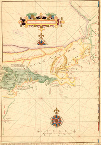
Figure 1.4a. [Map of New Netherland, the “Adrian Block Chart”], 1616. Copy of a nineteenth-century facsimile. From the American Geographical Society Library, University of Wisconsin-Milwaukee Libraries.
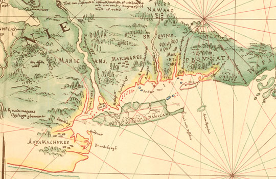
Figure 1.4b. [Map of New Netherland, the “Adrian Block Chart”], 1616. Detail showing lower New York. Copy of a nineteenth-century facsimile. From the American Geographical Society Library, University of Wisconsin-Milwaukee Libraries
This composite map was presented to the States General of the Netherlands in 1614 by the merchants who had sponsored Block’s voyage. They submitted the map as part of a claim seeking a trade monopoly in the area. Constituted as the New Netherland Company, they succeeded in obtaining a monopoly to conduct four voyages for each of three years. The existing Block Chart at the Royal Archives in The Hague is almost certainly a copy of the original, and may include omissions and errors introduced by the copyist. Since we only have a copy of the map, and do not know exactly what Block’s role was in producing it, it needs to be read with some caution. Nonetheless, it does provide, a good picture of what the Dutch knew about the Northeast around 1614, and there are no serious questions about its authenticity, as there are about the “Velasco Map.”
The part of the Block Chart that reflects discoveries made by Block himself includes the valleys of the Hudson and Connecticut rivers, as well as Long Island and the coast of Connecticut and Rhode Island. This is the first map that shows Long Island as an island, and to recognize the insular character of Manhattan. It is also the first to show the Connecticut River and the coast along the northern side of Long Island Sound. Block also rediscovered what is now known as Block Island (which had been called “Louisa” by Verrazano), and named it after himself. Block’s explorations took him as far as Cape Cod, and the map is sprinkled with Dutch place names as far north as southern Maine. Thus, Nantucket Sound is labeled the “Zuyder See” and Cape Cod Bay is called “Staaten Hoeck.” This practice of renaming geographic features after the home country is characteristic of colonial mapping, and is a way of laying claim to, and asserting control over, newly “discovered” lands. The practice conveniently ignores any claims to possession by the aboriginal inhabitants, and serves to preempt colonial rivals.[31]
The treatment of northern New York on the Block Chart is also revealing. The northernmost part of the map is the portion that is mostly derived from Champlain’s map of 1613, and which covers areas not visited by Block. Here the upper St. Lawrence River and the Ottawa River are depicted in a confusing way that appears to make them appear to be of equal size. The Ottawa River is shown branching in a peculiar fashion, which may indicate some confusion between the river and an outline of the shore of Lake Ontario. Ignorant though he was of the geography of this area, the person who made this portion of the map, and who was totally reliant on information from Champlain, did not hesitate to label the upper part of the St. Lawrence “The Great River of New Netherland.” Lake Champlain is depicted very much as it appears on Champlain’s maps of 1612 and 1613. It is displaced far to the east, and shown encircled by mountains.
A final feature worth noting on the Block Chart is its treatment of the area to the west of the Hudson River, which appears to be based on information gathered from the Indians by the Dutch, probably mostly by Block himself. The Mohawk River is clearly shown, as is a village of the Mohawk Indians. The Mohawk are called the Maquas or alternatively “canoemakers.” There is a note on the map indicating that the Mohawk were trading with the French along the St. Lawrence. The Mohawk River is shown flowing into a lake, which is probably Lake Oneida. The word “Sennecas” appears below the lake, along with the Gachoi (Cayuga) and the Capitannesses (Onondagas).[32] Evidently by then the Dutch had already heard of the Iroquois tribes in western New York, but here they are misplaced far to the east. These villages are located along a river shown flowing south from the lake. In spite of the names of Iroquois tribes, the river appears to represent the upper reaches of either the Delaware River or the Susquehanna River, although it is not shown flowing to the coast. The Susquehannocks (Minquas) are shown on the lower portion of the river. To put it mildly, this is a very confused representation of the region, and we will see that disentangling the upper branches of these two rivers was a major problem for map makers through most of the colonial era.
After Block departed for the Netherlands in 1614, the Onrust, was used for further explorations by Cornelis Hendricksen, which were eventually recorded on a work known as “the second figurative map.” [33] This map is now thought to have been compiled by the Dutch mapmaker Hessel Geritsz using information supplied by Hendricksen.[34]Hendricksen explored the Hudson River more thoroughly than Block had done, and he also made a careful reconnaissance of the coast of New Jersey and Delaware Bay. Hendricksen obtained information about the area west of the Hudson River from a fur trader named Kleytjen and a companion. They apparently traveled from the Fort Nassau area down the Susquehanna River. The story of Kleytjen casts a bit of light on Dutch-Iroquois relations at this early period. A note on the map, translated by Stokes, states “that [Kleytjen] also traded with the inhabitants of Minquaus (Sussquehannocks) and ransomed from them three persons belonging to the people of this Company, which three persons had suffered themselves to be employed by the Maquas (Mohawks) and Machicans (Mohicans); giving for them kettles, corals, and merchandise.”[35] This should be read alongside Champlain’s statement made in 1615 that the Dutch were fighting alongside the Iroquois against other Indians.[36] It appears that at least some of the Dutch were involved in military activities that have not otherwise come down to us.
This additional information is also recorded on the “second figurative map,” which is a subtly colored and beautiful bird’s eye view. The attractiveness of this map is not readily apparent in the black-and-white reproductions, which are most commonly seen. The second figurative map covers a smaller area than the Block Chart, focusing on the area between the Hudson and the Susquehanna Rivers. The depiction of the Hudson River is more detailed and accurate than on the Block Chart, and it provides valuable information about local Indians as well as about the state of Dutch geographical knowledge of the area. On this map, a number of familiar Dutch names appear along the Hudson River, including Esopus and Kinderhook. The names and locations of Indian tribes are presented in considerable detail, and have been analyzed by Shirley Dunn.[37] The depiction of the area west of the Hudson, which is probably based solely on the oral account received from Kleytjen, is very confused, but expands somewhat on the information on the Block Chart, which evidently used some of the same sources. As on the Block Chart, a segment of the Mohawk River is depicted, but it is not shown as joining the Hudson. Below the Mohawk River, there is a large lake labeled “fresh water,” which somewhat resembles Lake Oneida in shape, but which could just as well be a distorted representation of Otsego Lake. Once again, the names of the Iroquois tribes are written below, with the Oneida (Jottecas) now being added to the list. On this chart, however, the Susquehanna River is shown flowing out of the lake, which strengthens the Otsego hypothesis. Most likely, the information on this map is a conflation of the two lakes.
On the Second Figurative Chart, The Susquehanna River is shown flowing to the coast, although it is shown emptying into Delaware Bay just south of the Delaware River. Various Indian tribes are indicated along the Susquehanna, including the Susquehannocks (Minquas) near its mouth. Drawings of palisaded villages of the Susquehannocks are sketched inapparently the first drawings of Indian fortifications in the New York area to appear on a map. Reflecting Hendrickson’s own discoveries, the lower part of the Delaware River is clearly shown, although there is still a lot of confusion between the upper reaches of the Delaware and Susquehanna Rivers. The compiler of the second figurative map (in this case probably Gerritsz rather than Hendrickson) was aware of the confusions underlying this portion of the map, and acknowledged his uncertainty with admirable candor:
Regarding what Kleyntjen and his companion have told me of the situation of the rivers, and the places occupied by the tribes, which they found going inland away from the Maquaas and along the New River down to the Ogehage (namely the enemy of the aforesaid northern nations,) I cannot at present find anything but two sketches of small maps relating thereto, partly finished.
And when I think how best to make the one correspond with the rough notes, to the best of my knowledge I find that the dwelling-places of the Sennecas, Gachoos, Capitannasses, and Jottecas, ought to have been indicated rather more to the west.[38]
It was not until well into the eighteenth century that a reasonably clear picture of the relationship between the branches of the upper Delaware and the Susquehanna Rivers was to emerge.
For all practical purposes, the two “figurative maps” constitute the full extent of surviving Dutch mapping of New Netherland prior to 1630. There are a few other manuscript and printed maps, but they reveal little additional information. Starting around 1617, small-scale printed maps of North America started to show the territory the Dutch claimed as New Netherland. The earliest and best known of these is Willem Janszoon Blaeu’s Paskaart van Guinea, Brasilien en West Indien (ca. 1621).[39] Only after 1630 do we start to get more detailed printed maps. The two figurative maps were eventually used as the basis for the first reasonably large-scale printed maps of New Netherland, which were published by De Laet in 1630 and by Blaeu in 1635. The next important manuscript maps also date from after 1630. This later phase of Dutch mapping will be discussed in the following chapter.
Champlain’s famous map of New France made in 1632 provides a good summary of the geographical knowledge of the Northeast gained in the first three decades of the seventeenth century (Figure 1.5).[40] For the modern reader, it provides an immediately recognizable overview of the entire area between Chesapeake Bay and Hudson’s Bay. Although many features appear distorted to our eyes, almost all of the major coastal landmarks, islands, rivers, and lakes can be discerned.
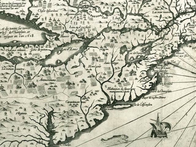
Figure 1.5. Samuel de Champlain, Carte de la Nouvelle France, 1632 . Detail courtesy of the Norman B. Leventhal Map Center at the Boston Public Library.
Focusing on the area comprising present-day New York, we can also recognize most of the major landmarks. Champlain’s depiction of northern New York is little changed from his map of 1612, and on the whole it is slightly inferior, perhaps in part because of its smaller scale. Lake Champlain, which is still exaggerated in size and shifted much too far to the east is the most prominent feature in northern New York. In central and western New York we can recognize Lake Ontario, some of the Finger Lakes, and the Iroquois villages in their vicinity. On the other hand, Lake Oneida is not clearly differentiated from the Finger Lakes, and Lake Erie is reduced to a kind of channel connecting Lake Ontario and Lake Huron.
The depiction of southern New York on Champlain’s map of 1632 is an intriguing mystery. Although he provides only a small amount of detail, Champlain does a good job of capturing the basic features of the area. Long Island is shown with approximately the right size and proportions. Islands are shown in the mouth of New York Harbor, and the Hudson River is shown flowing to the north. Even the Mohawk River appears, although it is depicted as flowing north, rather than west. The course of the Delaware River is also delineated with reasonable accuracy.
Champlain never explored this area, and it would be reasonable to assume that he copied this information from a Dutch map of New Netherland. However, that does not seem to be the case. Champlain’s depiction of the above-mentioned features does not resemble that on either of the two “figurative maps” discussed above. The only printed map that Champlain could have used was the one published by Johannis De Laet in 1630 (discussed in the next chapter), which was based almost entirely on the figurative maps. Overall, De Laet’s map bears little resemblance to Champlain’s, and De Laet makes some conspicuous errors derived from the figurative maps that would have almost certainly be found in Champlain’s map if he had relied on De Laet as a source.
Thus, Champlain’s depiction of southern New York depends either on unknown Dutch sources, or on some unknown French source. A fairly strong case can be made for a French origin for this portion of Champlain’s map. Champlain uses several French place names that do not appear on any other maps (except those derived directly from this one). Long Island is called “Isle de l’Ascension” (Ascension Island), the Hudson River appears as the “Rivière des Trettes” (River of Traders), and an Indian village east of the Hudson is called the “Habitation de sauvages maniganaticouoit” (settlement of the Maniganaticouoit Indians)a group that can not otherwise be identified. Stokes noted the appearance of these names, and could not explain their origins. To the best of my knowledge the mystery remains unsolved.
There are some indications of a French presence along the Hudson River in the first decades of the seventeenth century. One of the most intriguing is an annotation on the Block Chart, which has been translated as follows: “But as far as one can understand by what the Mohawk say and show, the French come with sloops as high up as their country to trade with them.”[41] This notation, which Block placed on his chart near present day Albany, lends itself to more than one interpretation. It seems to refer to French ships actually sailing up the Hudson River, but it might also be a confused reference to French goods being transported by Indians from the Saint Lawrence River via the Lake Champlain route. Another, and more certain, reference to early French activities on the Hudson River comes from 1624, when Dutch colonists arriving at the mouth of the Hudson found a French ship, which they escorted out of the river.[42] Perhaps a lucky researcher in French archives will someday make a discovery that will throw more light on early French activities in southern New York, and on the origins of the names on Champlain’s map.
Regardless of the sources he used, Champlain’s 1632 map stands as a magnificent summary of these early explorations. Champlain is recognized as being the most technically skilled mapmaker of all the early explorers of the Northeast, and he seems to have developed the ability to select out valid information from sources of varying quality. Throughout the remainder of the colonial period, explorers and map makers had the more mundane tasks of verifying, correcting, and filling out the picture established by their pioneering predecessors in the early seventeenth century.